| Sub categories | Details / Legends / Copyright / Map Links | |
|
|
||
Agriculture |
|
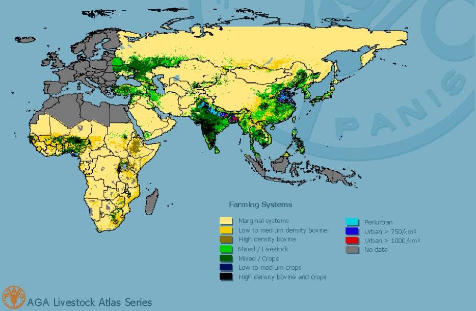
Major farming systems in Africa and Asia © FAO |
|
|
|
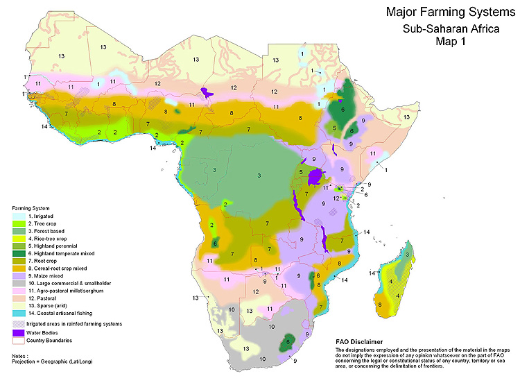
Farming systems in sub-saharan Africa A farming system is defined as a population of individual farm systems that have broadly similar resource bases, enterprise patterns, household livelihoods and constraints, and for which similar development strategies and interventions would be appropriate. Depending on the scale of the analysis, a farming system can encompass a few dozen or many millions of households. © FAO |
|
|
|
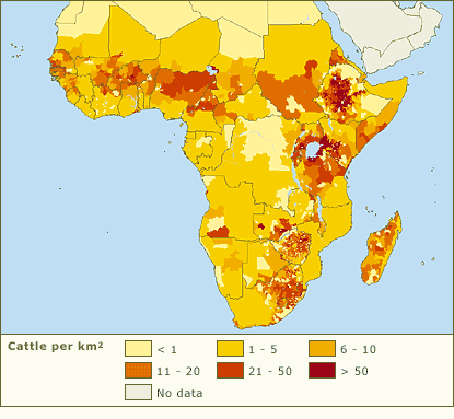
Cattle density in Africa This map plots the density of cattle in Africa and has been compiled by the International Livestock Research Institute (ILRI). This map shows the highest densities (between 20 and more than 50 cattle per km²) across an east-west band of northern grassland, and along a northeast-southeast band of eastern grassland. Countries with the highest densities include Ethiopia, Kenya, Uganda, Tanzania, Zambia, Zimbabwe, South Africa, and Madagascar. © World Resources Institute |
|
|
|
|
|
|
|
|
|
|
|
|
|
|
|
|
|
Biodiversity |
|
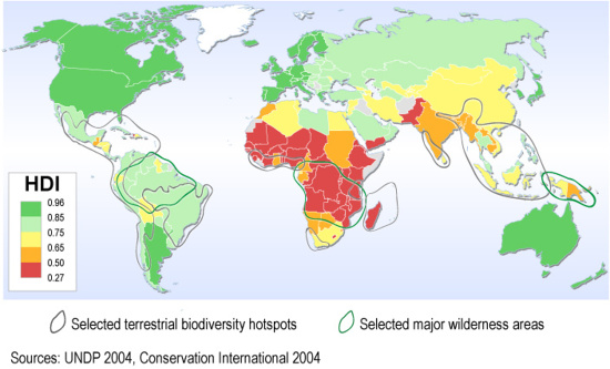
Global development and biodiversity Some of the world's least developed countries are located in hotspot areas of high importance for biodiversity. This map displays Human Development Index (UNDP) by country and hotspot regions overlaid on that. © 2006 UNEP/GRID-Arendal |
|
|
|
Global poverty and biodiversity Areas where high poverty and high population density coincides with high biodiversity may indicate areas in which poor people likely have no other choice than to unsustainably extract resources, in turn threatening biodiversity. © 2006 UNEP/GRID-Arendal |
|
|
|
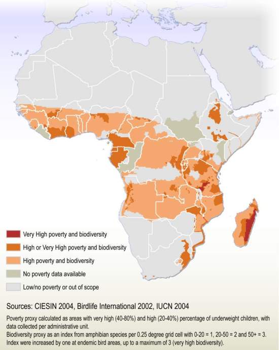
Poverty and biodiversity in Africa Areas where high percentage of underweight children - used as a proxy for poverty - coincide with a high occurrence of amphibian species and endemic bird areas - a proxy for biodiversity - may indicate areas in which poor people likely have no other choice than the unsustainable extraction of resources, in turn threatening biodiversity. © 2006 UNEP/GRID-Arendal |
|
|
|
|
Climate |
|
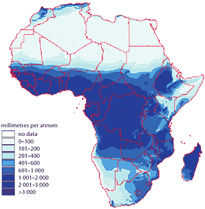
Annual rainfall Africa is characterized by considerable climatic variations, both spatial and temporal, and extreme events such as flooding and drought have been recorded for thousands of years. The equatorial belt generally has high rainfall, whereas northern and southern African countries and those in the Horn of Africa are typically arid or semi-ari. All parts of Africa, even those that usually have high rainfall, experience climatic variability and extreme events such as floods or droughts. © FAO |
|
|
|
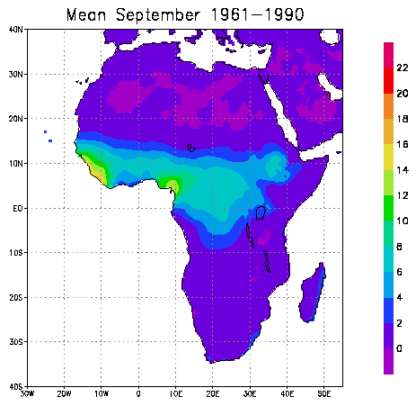
Mean monthly rainfall 1961-1990 (animated gif) © CLIVAR VACS African Climate Atlas |
|
|
|
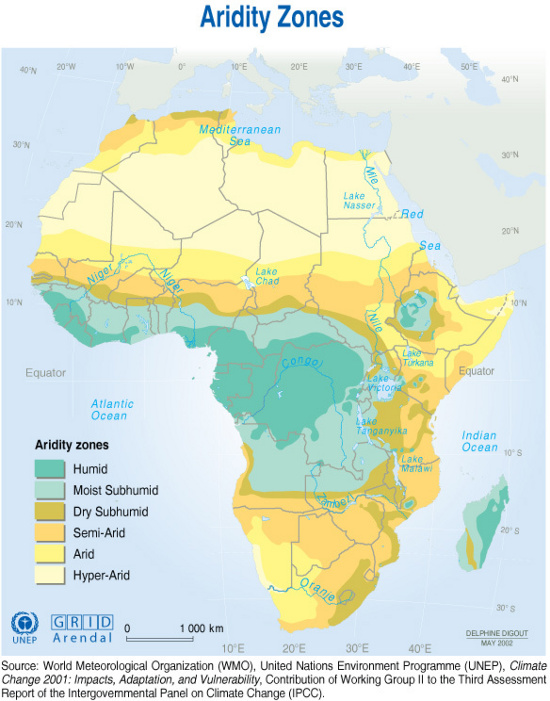
Aridity Some regions are particularly vulnerable to reduced precipitation. A significant part of the African continent is dry. The climate trend is longer periods of drought, shorter periods of heavy rain. Arid, semiarid, and dry sub humid areas include those lands where the ratio of precipitation to potential evaporation (PET) ranges from 0.05 to 0.65. In Africa, these conditions cover 13 million km2 or 43% of the continent's land area, where 270 million people, or 40% of the continents population, live. © UNEP |
|
|
|
|
|
Water |
|
Africa is the worlds second driest continent, after Australia (Revenga and Cassar n.d.). Freshwater is unevenly distributed across countries and regions due in large part to the variability of rainfall in different climatic zones. The countries that use the most water by volume are Egypt, Sudan, Madagascar, South Africa, Morocco, Nigeria, and Mali, but these are not necessarily the most water-rich nations. © UNEP |
|
|
|
|
Disasters |
|
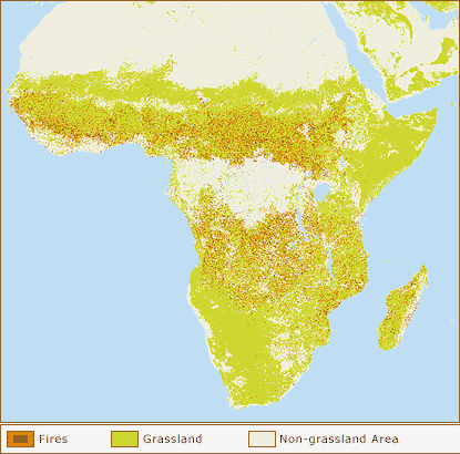
Grassland fires This map shows the location of all fires detected during 1993. Fire on the African continent appears to be confined by the Sahara Desert to the north, by the Horn of Africa to the east, and by the Kalahari Desert to the south. Tropical rainforest serves as a fire boundary with fires greatest in the grasslands on either side of the equator. © World Resources Institute |
|
|
|
Global fire regimes Percentage of the total surface area of each 1/2 degree cell burned in the year 2000 - based on the GBA2000 dataset. © TEM Terrestrial Ecosytem Monitoring |
|
|
|
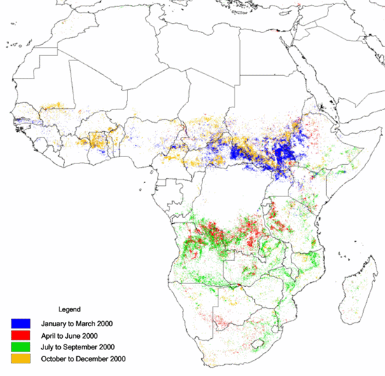
Seasonal global fire regimes Spatial and temporal distribution of burned areas for the year 2000 - based on the GBA2000 dataset. © TEM Terrestrial Ecosytem Monitoring |
|
|
|
|
Human density |
|
Global human population density for 1994. Downoload higher resolution jpeg file here (>2 Mo). © US Department of Agriculture |
|
|
|
|
|
|
|
|
|
|
|
|
Human impact |
|
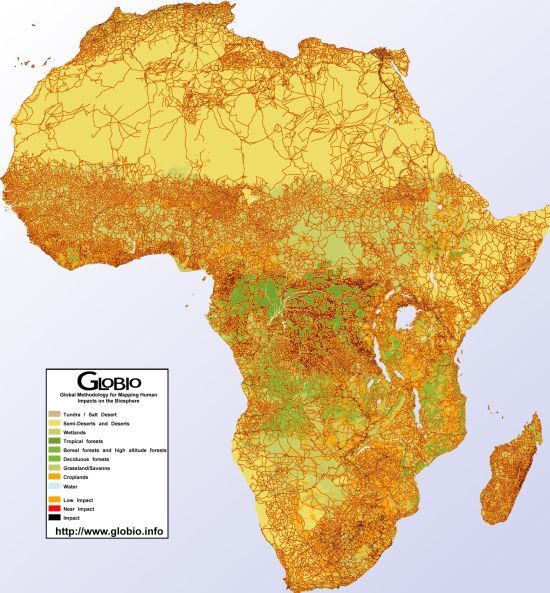
Human impact in Africa (>400ko) Africa is home to some of the greatest wilderness areas in the world, as well as some of the greatest biodiversity hotspots. The GLOBIO analysis shows that the great deserts and the Central African rain forests have huge remaining tracts that show low human impact and development. © GLOBIO |
|
|
|
|
Protected area |
|
|

